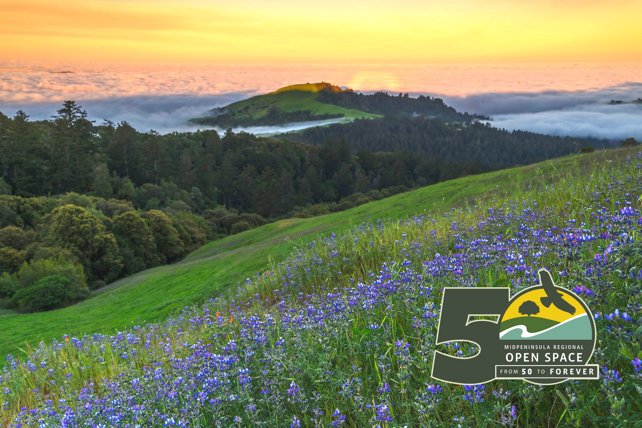
Created in 1972, Midpen is an independent special district that helps plants, animals and people thrive throughout the greater Santa Cruz Mountains region by preserving a connected greenbelt of more than 70,000 acres of public open space. These diverse and scenic landscapes, from bay wetlands to redwood forests and coastal grasslands, host an incredible diversity of life, making our region one of the world’s biodiversity hotspots.
Midpeninsula Regional Open Space District
Verified
Share
Favorite
Social
Contact Information
Phone Number
650-691-1200Website
https://www.openspace.org/Email
info@openspace.org
Find Your Community
Articles
5 Items
Related Locations
Outings
- Alpine Pond Habitat Hike
- Explore the New Ravenswood Bay Trail (English & Spanish)
- Grabtown Gulch-Borden Hatch Loop
- Purisima Creek Trail
- Redwood Trail
- San Andreas Fault Trail
- Seven Springs to Hunter's Point
- Triple Loop Hike: Los Trancos Preserve
- Unique and Unusual: Pulgas Ridge Preserve
- Upper Lake Interpretive Walk
- Water Wonders along the Stevens Creek Nature Trail
- Zinfandel Trail and Orchard Loop
Areas
- Bear Creek Redwoods Open Space Preserve
- Coal Creek Open Space Preserve
- El Corte de Madera Creek Open Space Preserve
- El Sereno Open Space Preserve
- Foothills Open Space Preserve
- Fremont Older Open Space Preserve
- La Honda Creek Open Space Preserve
- Long Ridge Open Space Preserve
- Los Trancos Open Space Preserve
- Monte Bello Open Space Preserve
- Picchetti Ranch Open Space Preserve
- Pulgas Ridge Open Space Preserve
- Purisima Creek Redwoods Open Space Preserve
- Rancho San Antonio County Park & Open Space Preserve
- Ravenswood Open Space Preserve
- Russian Ridge Open Space Preserve
- Saratoga Gap Open Space Preserve
- Sierra Azul Open Space Preserve
- Skyline Ridge Open Space Preserve
- St. Joseph's Hill Open Space Preserve
- Stevens Creek Shoreline Nature Study Area
- Teague Hill Open Space Preserve
- Thornewood Open Space Preserve
- Windy Hill Open Space Preserve
Trails
- Polly Geraci Trail
- Priest Rock Trail
- Purisima Creek Trail
- Quarry Trail
- Rainbow Knoll Trail
- Ranch Road
- Ranch Spring Trail
- Rancho San Antonio Service Road
- Range Trail
- Ravensbury Trail
- Razorback Ridge Trail
- Red Mountain Trail
- Redwood Springs Trail
- Redwood Trail
- Regnart Trail
- Resolution Trail
- Rhus Ridge Trail
- Ridge Trail
- Ridge Trail Bypass
- Rogue Valley Trail
- Saratoga Gap Trail
- Schilling Lake Trail
- School Road
- Sequoias Trail
- Serenity Trail
- Serpentine Trail
- Seven Springs Loop Trail
- Sierra Morena Trail
- Skid Road Trail
- Skyline Christmas Tree Farm Network
- Skyline Trail
- South Leaf Trail
- Spring Board Trail
- Spring Ridge Trail
- Steam Donkey Trail
- Stephen E. Abbors Trail
- Stevens Creek Nature Trail
- Sunny Jim Trail
- Tafoni Trail
- Tafoni Trail Spur
- Timberview Trail
- Timberview Trail Spur
- Toyon Trail
- Tree Farm Trail
- Upper High Meadow Trail
- Upper Lake Loop Trail
- Upper Rogue Valley Trail
- Upper Wildcat Canyon Trail
- Virginia Mill Trail
- Vista Loop Trail
- Vista Trail
- Ward Road
- Waterwheel Creek Trail
- Wedding Trail
- White Oak Trail
- Whittemore Gulch Trail
- Wildcat Loop Trail
- Woodhills Loop Trail
- Woods Trail
- Zinfandel Trail
Points of Interest
- Achistaca Trailhead
- Alpine (upper) Trailhead
- Ancient Oaks Trailhead
- Anniversary/Lost Trailhead
- Audrey C. Rust Commemorative Site
- Bald Mountain
- Bald Mountain/Mt. Umunhum (lower) Trailhead
- Bay Trail at Ravenswood/Cooley Landing Trailhead
- Bear Meadow Trailhead
- Black Mountain Backpack Camp
- Blue Oak Trailhead
- Bridle Trailhead
- Ceremonial space
- Clouds Rest Trailhead
- Coho vista point
- Cora Older Trail at Prospect Rd Trailhead
- Coyote Trailhead
- Crazy Pete's Trailhead
- David C. Daniels Nature Center
- Deer Hollow Farm
- Drinking water
- Drinking water
- East summit viewpoint
- Equestrian parking area at El Corte de Madera
- Equestrian parking area at Rancho San Antonio
- Equestrian parking area at Skyline Ridge
- Faultline Trail Station #1
- Faultline Trail Station #2
- Faultline Trail Station #3
- Faultline Trail Station #4
- Faultline Trail Station #5
- Faultline Trail Station #6
- Faultline Trail Station #7
- Faultline Trail Station #8
- Faultline Trail Station #9
- Foothills Vista Trailhead
- Fremont Older historic house
- Grabtown Gulch Trailhead
- Guadalupe Creek overlook
- Harrington Creek/Sears Ranch Trailhead
- Hickory Oaks Trailhead
- Horseshoe Loop Trailhead
- Hunter's Point
- Ipiwa / Sunny Jim (West) Trailhead
- Ipiwa/Sunny Jim (East) Trailhead
- Jones Trailhead
- Kennedy Trailhead
- Maisie's Peak
- Meadow Trailhead
- Memorial for DC-6 "Resolution" airplane crash
- Methuselah at Star Hill Rd Trailhead
- Methuselah Trailhead
- Mindego Hill Trailhead
- Montevina Ridge Trailhead
- Mount Umunhum Summit Area
- Mt. Umunhum Trailhead (upper)
- North observation platform
- North Ridge Parking Area
- North Ridge Trailhead
- Off-leash dog area
- Old-growth redwood
- Page Mill Trailhead (LT01)
- Parking area at Bear Creek Redwoods
- Parking area at El Corte de Madera
- Parking area at Fremont Older
- Parking area at La Honda Creek
- Parking area at Los Trancos
- Parking area at Monte Bello
- Parking area at Mount Umunhum
- Parking area at Picchetti Ranch
- Parking area at Pulgas Ridge
- Parking area at Rancho San Antonio #1
- Parking area at Rancho San Antonio #2
- Parking area at Rancho San Antonio #3
- Parking area at Rancho San Antonio #4
- Parking area at Rancho San Antonio #5
- Parking area at Ravenswood
- Parking area at Russian Ridge (Mindego Gateway)
- Parking area at Russian Ridge (Skyline Blvd)
- Parking area at Saratoga Gap (CalTrans)
- Parking area at Sempervirens Point (CalTrans)
- Parking area at Sierra Azul (accessible-only)
- Parking area at Sierra Azul (Bald Mountain)
- Parking area at Sierra Azul (Jacques Ridge)
- Parking area at Skeggs Point (CalTrans)
- Parking area at Skyline Ridge (east)
- Parking area at Skyline Ridge (west)
- Parking area at Thornewood
- Parking area at Windy Hill (Portola Road)
- Parking area at Windy Hill (Skyline Blvd)
- Permit parking in northern La Honda Creek
- Permit-only equestrian parking area at Event Center
- Permit-only equestrian parking area at MB04
- Permit-only parking area at Lower Meadow
- Permit-only parking area at Overlook Drive
- Permit-only parking at Water Wheel Creek Trail
- Peters Creek Trailhead
- Picchetti Winery historic buildings
- Picnic table
- Picnic table