Add your organization to OuterSpatial. Get started now for free.
image.png

Kamananui Valley Road

Trail in Honolulu Watershed Forest Reserve

0 Reviews

Report

Report incorrect or missing information.

Details:

  • Length (one way): 4 mi / 6.44 km
  • Elevation Change: 600 ft / 182.88 m

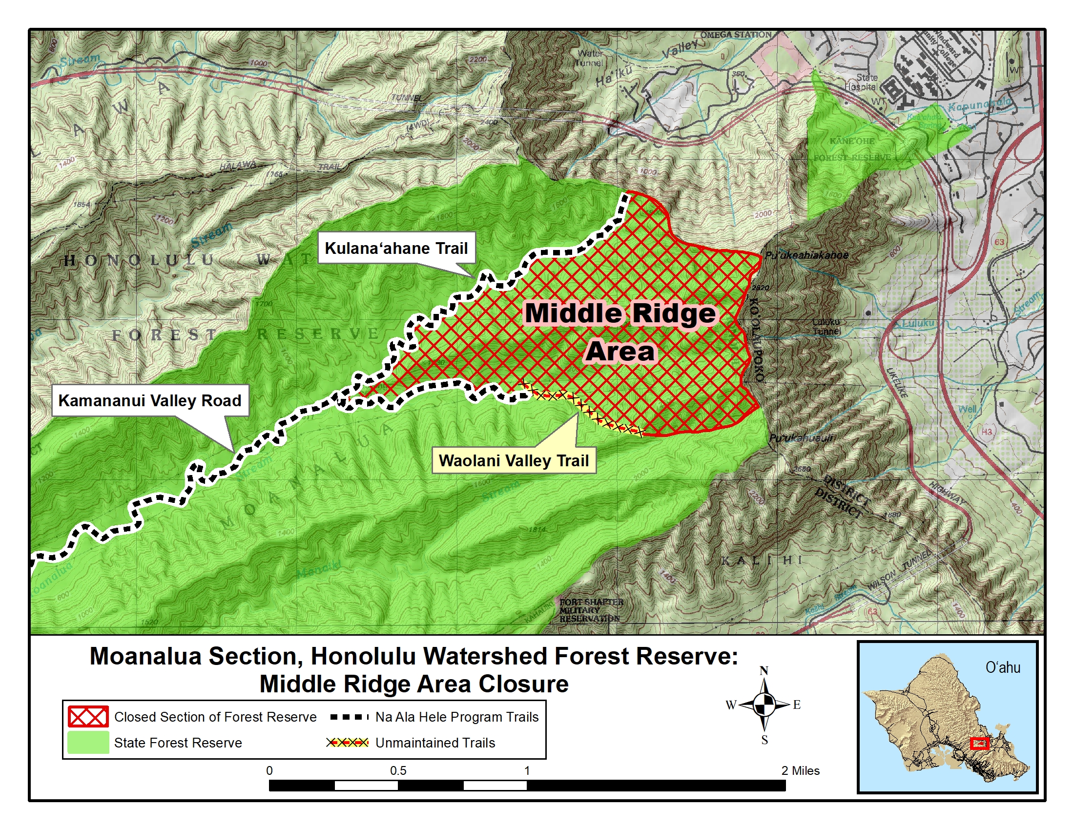
Once you are at the park proceed up the dirt road to the chain link gate. The gate will have regulation and safety information signs on it. Please read the signs and proceed up the road. This road is an easy hike through the lush forest of Kamananui Valley. Along the way, you will see numbered post that are references for a brochure once handed out to the public by the Moanalua Gardens Foundation. The Na Ala Hele program will be placing new interpretive signs at these sites. The road is unimproved and is only used by vehicles for management. Permits are not issued for public vehicle use of this road. The road has seven bridges that are accompanied with stream fords (armoured stream crossing). The road is a total of 4 miles from beginning to end. Making it 8 miles round trip. At roughly 2 miles up the road on your left is the Kulana‘ahane trail.

Descriptions for route, history, plants and birds were provided by Stuart Ball, author of The Hikers Guide to Oahu and other hiking books.

Campsites not designated. Camping is allowed with permit anywhere within the trail corridor (10 feet from center line) except for at the "Education Forest Project Site."  Permit must be printed, signed and in your possession while camping.

As access to campsites requires stream crossings, IT IS NOT RECOMMENDED TO HIKE THIS TRAIL DURING HEAVY RAINS due to the possibility of flash flooding.

For more information visit State of Hawaii Camping website: https://camping.ehawaii.gov/camping/all,details,31721.html

Additional Information

Allowed Access
Bicycles
Dogs
Pedestrians
Activities
Dog Walking
Hiking
Mountain Biking
Road Biking
Rules & Regulations
Carry Out Trash
Dogs On Leash
No Campfires
No Horses
No Motorized Wheeled Vehicles
Pack Out Dog Waste
Stay On Trail
Features
  • Cultural Study
  • Nature Study
  • Open Views
  • Sensitive Area
  • Stream
Hazards
  • Blind Corner
  • Dangerous Footing
  • Flash Flood
  • Hunting Area
  • Stream Crossing
  • Uneven Surface
Mountain Bikers

Always yield to hikers. Do not slide around corners or slide down the trail. Careless mountain biking damages the trail and causes erosion. If accidents are reported or damage to the trail is extreme, the trail may be closed to mountain bikers.

Campers

A City and County park located at the start of this trail provides bathrooms, potable water and garbage cans. However, no such facilities are available within the valley itself. Make no mistake, this is "roughing it" back country camping. If it rains and you don't have the right gear it can be miserable. Non-potable stream water can be found through out the valley. All water should be treated. Camp sites are not designated. Therefore, you may need to go off the trail to find flat areas to camp. There may be better camping sites along the Kulana‘ahane trail further up the road on the left. There are nice spots along the stream that are very suitable for camping. As access to campsites on the Kulana‘ahane trail will require stream crossings, IT IS NOT RECOMMENDED TO HIKE THIS TRAIL DURING HEAVY RAINS due to the possibility of flash flooding. Campers must find legal parking in the adjacent neighborhood. Please park responsibly and do not leave valuables in your vehicle.

Dog Owners

Hunting may be in progress on or near this hiking trail. Hunting dogs may be off-leash while engaged in the hunt. Hikers must keep their dogs leashed at all times and remove dog waste while on this trail.

Other Announcements

The Haiku Stairs are closed and access is not allowed.

Activities
  • Bicycle
  • Camping
  • Dog Hunting
  • Dogs on Leash
  • Hiking
Prohibited
  • No Alcohol
  • No Commercial
  • No Horses
  • No Littering
  • No Motorized Vehicles
  • No Open Fires
  • No Plant Sand Dirt Rock Removal
  • No Smoking
Terrain and Trail Environment

Mountainous, dirt road with bridges, some native forest.

Amenities & Facilities
  • Bike Rack
  • Bridge
  • Campsites
  • Drinking Water
  • Interpretive Signs
  • Parking
  • Picnic Table
  • Restroom
  • Trash Cans
  • Water Fountain
Simple Trail Tips:
  1. Stay on the trail
  2. Check the weather 
  3. Watch the time 
  4. Avoid undue risk
  5. Read all posted signs
  6. Respect other trail users
  7. Pack out at least what you pack in
The Haiku Stairs are closed

Accessing the Haiku Stairs is not allowed

Directions

If driving from Honolulu - Heading west on Lunalilo Fwy I-H1. Near Middle Street keep left on Rte 78. Continue to "Moanalua Valley" Exit 19B, - Once off the highway turn right on Ala Aolani Street. Continue on Ala Aolani to the back of the Moanalua valley - The Moanalua Valley Park is at the end of the road. Parking is for park users only. Therefore, please park outside the park and continue up the little dirt road that starts at the end of the park parking lot. Note: The gate is locked and the park is closed at a certain hour. The time should be posted on the gate.

Special Conditions

This trail is suitable for large hiking groups of more than 12 individuals or school groups. 

Do not use any trail or access road that is not delineated by name and color and that may also be displayed on these maps. The marked features are managed for public recreational use. Other trails or roads that branch off from the public features may be on private property, and are not managed for any public recreational use. Access is subject to adjacent landowner approval, and if used without authorization, you will be trespassing and possibly putting yourself at risk. 

Route Description

From Moanalua Valley Park proceed along Kamananui Valley Road, the one-lane dirt/gravel track at the back of the parking lot.

Squeeze to the right of a locked gate. On the left by a huge monkeypod tree pass a muddy driveway leading to the Douglas Damon house site. Cross Kamananui Stream seven times on stone bridges. The original cobblestones of the old carriage road remain intact on the bridge approaches at the fifth crossing. On the right under a mango tree at the seventh crossing is Pohakukaluahine, a large boulder covered with petroglyphs. Around the bend from the petroglyph rock and before the next stream crossing, reach a junction. Continue straight on the dirt road. (To the right a short loop trail leads up to the May Damon house site and a view up the valley.) Ford the stream four times and then ascend gradually to a wide vehicle turnaround area. On the right a short trail leads up to another overlook of the entire valley. After crossing the stream six more times reach a signed junction on the left across from a large koa tree. Continue straight on the road. (To the left the Kulana`ahane Trail meanders up the left fork of Kamananui Stream.) Ford the stream once again. Climb steadily toward the back of the valley, paralleling a powerline. Descend briefly and then resume the gentle ascent. Reach a junction Turn right through white ginger and cross the stream one last time. The road ends at a vehicle turnaround, currently overgrown with grass. At the far edge is an End of Trail sign.

Plants & Birds

Along the road look and listen for the white-rumped shama. The bird is black on top with a chestnut-colored breast and a long black-and-white tail. The shama has a variety of beautiful songs and often mimics other birds. A native of Malaysia, the shama has become widespread in introduced forests such as this one. Until the 1920s the owners grazed cattle in the valley resulting in the destruction of much of the original native vegetation. 

By the stream watch for tangled hau trees with large, heart-shaped leaves. Their flowers are bright yellow with a dark red center, and resemble those of a hibiscus. Early Hawaiians used the wood for kites and canoe outriggers, the bark for sandals, and the sap as a laxative. 

Lining the stream are kukui trees. Their large, pale green leaves resemble those of the maple, with several distinct lobes. Early Polynesian voyagers introduced kukui into Hawai`i. They used the wood to make gunwales and seats for their outrigger canoes. The flowers and sap became medicines to treat a variety of ailments. Early Hawaiians strung the nuts together to make lei hua (seed or nut garlands). The oily kernels became house candles and torches for night spear fishing.

History

Interpretive signs mark the many natural and cultural points of interest along the road. 

In 1884 Bernice Pauahi Bishop willed the entire ahupua`a (land division) of Moanalua (two camps) to her husband's business partner, Samuel M. Damon. His son, Douglas, built a luxurious mountain house in the valley, which was originally known as Kamananui (great spiritual power). A cobbled carriage road crossed seven ornate bridges and ended at the house of his daughter, May Damon. 

After the last bridge look for Pohakukaluahine (rock of the old woman), a sacred boulder covered with ancient petroglyphs. Most of the carvings are human stick figures, although a few resemble bird-men. Also on the boulder are a konane game board and a winding groove suggesting Kamananui Stream. A nearby sign retells the legend of Pohakukaluahine. 

Hawaiian Electric Company built the sections of the road bypassing the bridges and the rest of the road past the May Damon house. The company uses it to access a powerline, which goes to the back of the valley, vaults over the Ko`olau summit, and descends to the windward side.